The benefits
Lorem ipsum dolor sit amet consectetur. Dignissim et orci nec diam. Ac ante
cursus augue elit.
Make faster, better decisions
Turn complex data into clear insights using mapping, spatial analysis, and real-time visibility
Improve service delivery
Optimise operations, reduce manual processes and duplication, and respond more efficiently to community needs.
Plan with confidence
Support long-term planning with accurate, location-based insights and scenario modelling.
Deliver better community outcomes
Make informed decisions that directly impact people and places, and greater transparency through clear communication with the public and stakeholders.
Be future-ready
Support digital transformation initiatives, smart city and connected community programmes and data-drive planning and investment integration with emerging technologies, including AI.
Label
Explore what’s possible
GIS supports a range of functions across council, from zoning, consenting and spatial planning and managing roads, water and community facilities, to emergency management, property data and valuation accuracy, and service
delivery optimisation.
Label
Engage the community
Share district management plans, inform about upcoming projects, and promote interesting places and environments around the city or region.
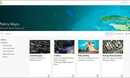
Take a look at how Palmerston North City Council is using its LocalMaps Gallery to share spatial information about its vibrant city.
Label
Explore Property information
Share accurate property records, visualize land ownership and encourage self-service mapping for your public users.
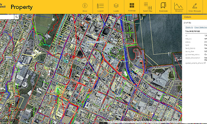
See how the Wellington City Council Property Map enables ratepayers to easily explore up to date property information.
Label
Visualize and manage land use
Identify and monitor land use, zoning, and other regulations that impact the environment and use of land.
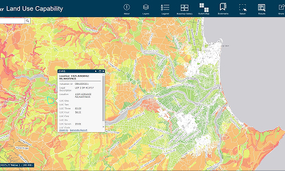
Hawkes Bay Regional Council are using LocalMaps to easily generate reports on Property land use in the region.
Real results in your sector
See how our products and services have transformed other businesses in your industry.


Label
Longer paragraph section
headline
We work with you every step of the way to design, implement, and support GIS solutions that deliver real value.
Lorem ipsum dolor sit amet consectetur. Proin ultrices commodo quis at enim sem aliquam elementum vitae. Aenean a at habitant facilisis tincidunt donec egestas. Semper massa dictum sed id arcu tristique semper quis elit. Id sit enim eleifend quisque aliquet facilisis. Eu elit bibendum quis enim.
Et nunc nisi aliquet id amet sapien faucibus. Sed amet quam amet pellentesque ac cursus massa. Sed nisi dictum dignissim enim sed. Ipsum mauris lorem tortor placerat parturient enim nisi commodo ultrices. Duis lectus a justo egestas tristique lorem aliquam quam. Montes arcu scelerisque vitae duis. Nunc lobortis est justo scelerisque. Convallis ultricies sed at etiam sed tempus ornare. Nibh leo semper aliquam vitae suspendisse nam. Lectus fermentum feugiat nulla pellentesque venenatis scelerisque tincidunt mauris nulla. Felis tellus tellus varius auctor sit curabitur. Et fermentum ullamcorper vitae ipsum.
Our approach
We work with you every step of the way to design, implement, and support GIS solutions that deliver real value.
Long-term partnerships
We build long-term partnerships, not one-off projects, working alongside councils across Aotearoa New Zealand to design, implement, and support GIS solutions that deliver real value.
Support to succeed
We work to understand how you operate and design tailored solutions around your workflows, and support adoption across teams and departments to ensure your team gets the most out of GIS to effectively support your communities.
Scalable solutions
Whether you re a small district council or large metropolitan authority, we can scale GIS solutions to suit different needs, budgets and levels of maturity, allowing councils to start small and expand over time, focus on priority use cases first and build capability gradually across teams.