Meet our Team
Chief Executive Officer
Graeme Henderson
Graeme Henderson was appointed Chief Executive Officer in 2025, marking a significant step in Eagle Technology’s continued growth. With more than a decade of leadership experience within the business, including his previous role as Sales Director, Graeme has led strategic transformation initiatives, expanded into new markets, and delivered sustained revenue growth. He brings a deep understanding of Eagle’s customers and operations, with a strong focus on innovation, high-performing teams, and delivering practical, end-to-end solutions.
Professional Services Manager
Chris Malcolm
Chris Malcolm leads Eagle Technology’s Professional Services team, bringing extensive experience in delivering geospatial and enterprise technology solutions. With a strong background in GIS and project delivery, Chris works closely with customers to ensure successful implementation and long-term value from their technology investments.
TEST
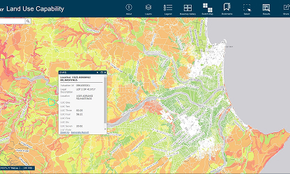
Visualize and manage land use
Identify and monitor land use, zoning, and other regulations that impact the environment and use of land.
Hawkes Bay Regional Council are using LocalMaps to easily generate reports on Property land use in the region.
Chief Executive Officer
Graeme Henderson
Graeme Henderson was appointed Chief Executive Officer in 2025, marking a significant step in Eagle Technology’s continued growth. With more than a decade of leadership experience within the business, including his previous role as Sales Director, Graeme has led strategic transformation initiatives, expanded into new markets, and delivered sustained revenue growth. He brings a deep understanding of Eagle’s customers and operations, with a strong focus on innovation, high-performing teams, and delivering practical, end-to-end solutions.
Label
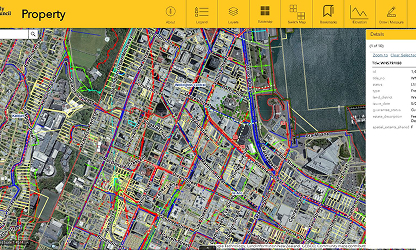
Explore Property information
Share accurate property records, visualize land ownership and encourage self-service mapping for your public users.
See how the Wellington City Council Property Map enables ratepayers to easily explore up to date property information.
Label
Visualize and manage land use
Identify and monitor land use, zoning, and other regulations that impact the environment and use of land.
Hawkes Bay Regional Council are using LocalMaps to easily generate reports on Property land use in the region.